On Wednesday, February 20th, we crossed the International Date Line, immediately moving us 23 hours into the future. The International Date Line is an imaginary line on the Earth’s surface that defines the boundary between one day and the next. Pam wanted to know why we have an International Date Line, and she found a terrific explanation at http://www.livescience.com/44292-international-date-line-explained. Here’s a synopsis….
Before mechanical clocks time was measured mostly by using sun dials. “Noon” was when the sun was highest in the sky and due south. A “day” was the time between two consecutive noons. That worked fine within each individual city; however, the introduction of transcontinental railroads and accurate time pieces in the 19th century complicated things a bit. “High noon” occurs at different times in different locations. Travelers would have to reset their watches by several minutes each time the train pulled into another station. Telegraphy also created issues for commercial and military entities. The telegraph, introduced in 1832 allowed communication over great distances using electricity, which moves at the speed of light. The telephone followed in 1876. To use either system effectively required knowing what time it was at both the sender’s location and the recipient’s location. Scientists, railroads, the military and others agreed it was time to create a global standard for time.
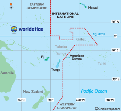
The first system for time was introduced in 1876. It wasn’t officially sanctioned by any particular country or global entity, but by 1900 it had led to the adoption of the time zone system we use today. To create a global time system the day and date have to be separated. The 180 degree meridian was chosen as the point of separation because it runs mostly through open water, creating the least amount of inconvenience for countries applying the standard. Although the date line runs along the 180 degree meridian, it is not a straight line (as shown on the map). And it can be moved!
In 2011, Samoa changed its timezone by shifting the dateline west and skipping December 30th. In previous centuries Samoa’s greatest trading partner was the U.S. Over time New Zealand and Australia became Samoa’s leading trading partners. They were geographically closer to these countries, but on opposite sides of the International Date Line, which meant there was a 23 hour time difference. This caused them two lose two trading days a week with their main trading partners. Changing the date line allowed them to better synchronize their work weeks. For 119 years Samoa had witnessed the last sunset of the day and were the last to ring in the new year. Now they are the first. Another fun fact: American Samoa, located on the same island as Samoa, did not make the change, so now there is a 24 hour time difference between Samoa and American Samoa!